The Karwendel High Alpine Trail
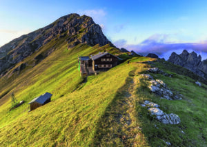
This six-day tour through the largest nature park in Austria is about so much more than simply 70 kilometres of hiking trails and a total of 9,000 metres of ascents and descents. The Karwendel High Alpine Trail offers the chance to explore the Karwendel mountains from the valleys to the summits in a very demanding multi-day tour, stay overnight in five outstanding mountain huts and experience the natural Alpine mountain environment with every step. This is a mountain trail in the black category (difficult). On the 5th stage there are also easy via ferrata passages of level A/B, if the Großer Bettelwurf peak is climbed.
A challenging mountain hut trail with guaranteed chamois sightings!
Welcome to the Karwendel High Alpine Trail!
The Karwendel High Alpine Trail takes you through the southern section of the Karwendel mountain range. What makes this tour unique is the frequent back-and-forth between the solitude of the Karwendel wilderness and the hustle and bustle of the Inntal valley. Observant mountaineers will also have the opportunity to discover a great many other creatures that live at these high altitudes. Visitors spend the nights in hand-picked mountain huts belonging to the Austrian Alpine Association that provide exceptional service and are well worth an extended stay. The Karwendel High Alpine Trail is not suitable for Alpine beginners or children, but is intended for experienced mountaineers who are surefooted, have a good head for heights and are in ideal physical condition to take on the various stages. It is a mountain trail in the black category (difficult), on the 5th stage there are also easy via ferrata passages of level A/B. The best time to hike the Karwendel High Alpine Trail is from July to September. Especially the late summer with its stable weather periods and excellent distant views is highly recommended.

Characteristics
Difficult, narrow and steep, very exposed, longer secured sections or climbing passages, marked and signposted
Prerequisite
Very good physical condition, mountain experience and recognition and assessment of alpine dangers on mountain trails, good weather conditions, sometimes alpine belay devices (Crampons, ice axe; a via ferrata set and helmet are also recommended for climbing the Großer Bettelwurf peak)
Target group
Free from giddiness, sure-footed, alpine experienced mountaineers
Overview of the Karwendel High Alpine Trail
Overview Map
The Karwendel High Alpine Trail is divided into 6 stages with a total difference in elevation of around 9,000 metres, including 4,400 metres of ascents. The path can be taken in both directions, i.e. from Reith to Scharnitz and from Scharnitz to Reith. For a better orientation we have added two different colours to the two walking directions on our homepage. For particularly ambitious mountaineers, there is also the opportunity to take in a number of rewarding peaks such as the Stempeljochspitze. It is possible to join and leave the route from any of the mountain huts and two cable cars can help considerably shorten the first and third stages. As it is very easy to make your way here via public transport, we recommend that you use this option. The six stages of the Karwendel High Alpine Trail can also be divided into two or three dates, as desired, and are thus also suitable for weekend excursions.

The Karwendel High Alpine Trail in detail
Reith to Scharnitz
Detailed information is provided for the respective stages and can also be downloaded as a PDF to print out. All stages are also shown on the interactive map, which makes it much easier to plan your tour. Nevertheless, we recommend that you use the Karwendel High Alpine Trail brochure together with a classic hiking map featuring a scale of 1:50.000 or better.

The Karwendel High Alpine Trail in detail
Scharnitz to Reith

Blog Moon & Honey Travel
Moon & Honey Travel were on the Karwendel High Alpine Trail in 2020 and provide all information and reports in english when you want to hike in direction from Scharnitz to Reith on their blog. They also have completed some additional peaks off the high trail along the way.
The latest information on the Karwendel High Alpine Trail
Status Report
As a mountaineer on the Karwendel High Alpine Trail, you will largely find yourself on black mountain trails. It goes without saying that heavy rain, storms and other environmental influences may have an adverse impact on the trails and may prevent the immediate repair of any damage that occurs despite our best efforts. We therefore strive to provide the latest details on the situation while bearing in mind that this information can never be entirely up to date. The top priority for mountaineers on mountainous terrain is thus to take personal responsibility, maintain caution and be aware. For detailled information please call the tourist information or check our Facebook page for information in german.


Current weather conditions
When it comes to mountaineering in the Alps, the weather plays a particularly decisive role. Thoroughly informing yourself of the prevailing weather conditions is an essential part of proper tour planning. A basic overview is provided below, although it is always sensible to obtain more precise information from outlets such as the Alpine weather service of the Austrian Alpine Association.

Public Transport
As you make your way along the Karwendel High Alpine Trail, you car can take a break. The start and end points are both very easy to access by bus and rail, ensuring a relaxed journey before you start your tour.
We’ve got you covered
Info & Service
We believe it is very important to ensure that all the preparatory information you need for your Karwendel High Alpine Trail tour is available on our website, which is why we have created a comprehensive service area. If you have any further questions or if you need assistance with booking a place at the mountain huts, our Karwendel High Alpine Trail experts will be happy to help.